© bOURNE uNIVERSITY 2021
New Model Reveals Evidence of a First Ancient
"Archean Continent" - Part One
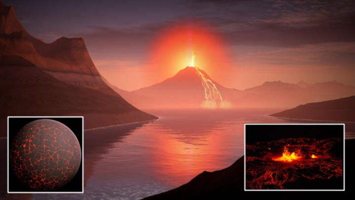
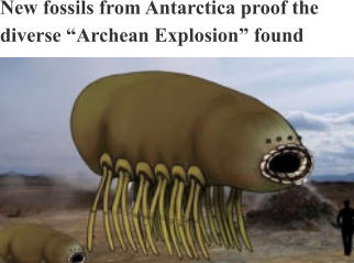
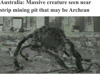
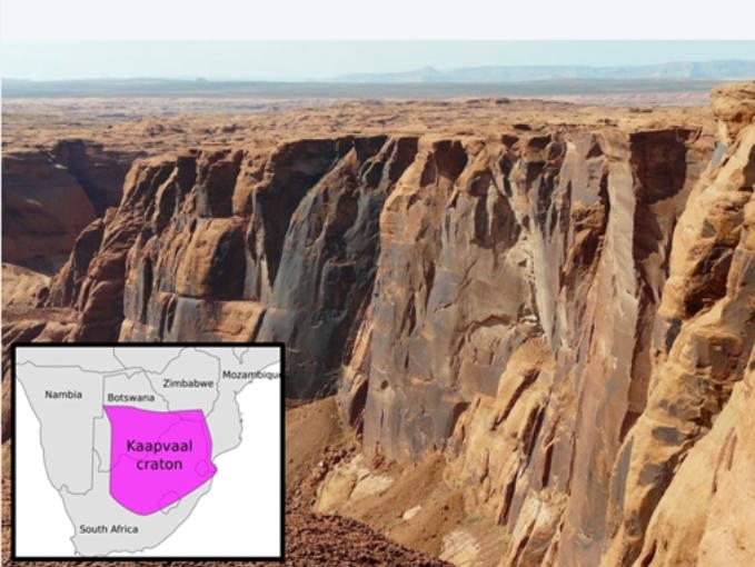
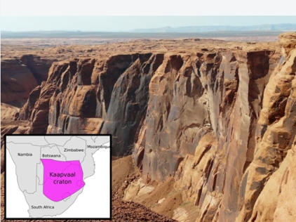
Data from a NASA and ESA satellites imaging Antarctica's graveyard of age old continental remains has uncovered the ancient cratons of an Archean landmass. The first continent of Yidath, as rendered by geological artists based on craton and deep sea radar investigations from Australia on to the shores of Antarctica. Preliminary evidence shows very highly developed organic structures and atmospheric evidences, based on fossils discovered in Antarctica. During the modern area. the theory that the Archean Eon - from nearly 4.0 billions years ago - was preceded by the great geological upheavals and a molten state of the Hadean Eon has been accepted by academics and scientific circles alike. The earth's atmosphere, according to theory, had no free oxygen but was composed of nitrogen and methane. The crusts had begun to form. The primitive oceans began to appear during the earliest Archean (Eoarchean Era) with abundant volcanoes outgassing with the condensation for water. The carbon dioxide flows from these same volcanoes also contributed to the creation of the world's atmosphere, ozone layer and great oceanic ridges that formed thick oceanic plateaus. The globe then cooled, gradually providing the stable environment needed for early landforms and life to arise - prkaryotic microbes - which appeared some 3.5-3.7 billion years ago. Current theories suggest the Archean Earth of four billion years ago was beginning to cool down and see the formation of continents, the stable formation of an atmosphere of methane and oceans trapping oxygen in water form. Nearly 2.7 billion years ago, bluish- green microscopic organisms called cyanobacteria began to flourish in Earth's oceans. The moon began to form during this period. But with the analysis of records from Karvon University, using data from NASA’s newest satellite mission, the Ice, Cloud and land Elevation Satellite-2 (ICESat-2), having provided detailed geological images of Antarctica from space, evidence from previous satellites has shed light on a mystery that may question this geological speculation. The European Space Agency's Gravity Field and Ocean Circulation Explorer program was discontinued over six years ago and was studying how gravitational fields effect areas of the Earth. This also included the investigation of geological data from Landsat 8 launched in 2013 and the Terra satellite launched into Earth orbit by NASA in 1999. Using Japan's Advanced Spaceborne Thermal Emission and Reflection Radiometer (ASTER), the Terra satellite provided data used to create detailed maps of surface height elevations of land, emissivity, reflectance, and elevation. But with the help of data from these discontinued European and American satellites, not only had scientists discovered that East Antarctica has large mass of continental remains from the prehistoric past, but that neighboring landmasses like Australia and India could contain evidences of a first, unknown and unspeculated Archean continent. Photo: Geological continental barrier in southern Africa (Kaapval Craton). Current geological theories indicate the first modern landmass that formed was Pangea. Pangea was a supercontinent that arose during the late Paleozoic and early Mesozoic eras. It assembled from earlier continental fragments 335 million years ago, and fragmented itself about 175 million years ago. Ur, a proposed first Archean continent with some evidence, had been accepted to be the stable 'first' based on geological cratons. Scientists have created stunning 3-D maps of the southernmost Earth's tectonic crust substructures and have found that these continent's coastlines, when fractured crusts based on geological similarities are assembled from various coastlines shows how this hypothetical landmass of the ancient Archean supercontinent was assembled and then spectacularly destroyed. The scientists, led by Alfred Wegener, a geophysicist at West Ashington University in Helsinger, Denmark, announced their research findings later this year in Science Daily News. "If our theory proves to be correct, it may require revision to many aspects of our understanding of the Earth's geological and prehistoric histories, including the epochs of the past continents and possibly even the onset of plate tectonics."AN ANTARCTIC DISCOVERY
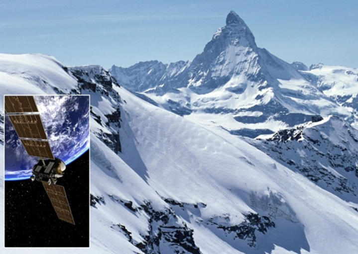
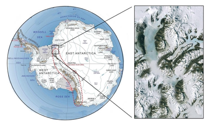
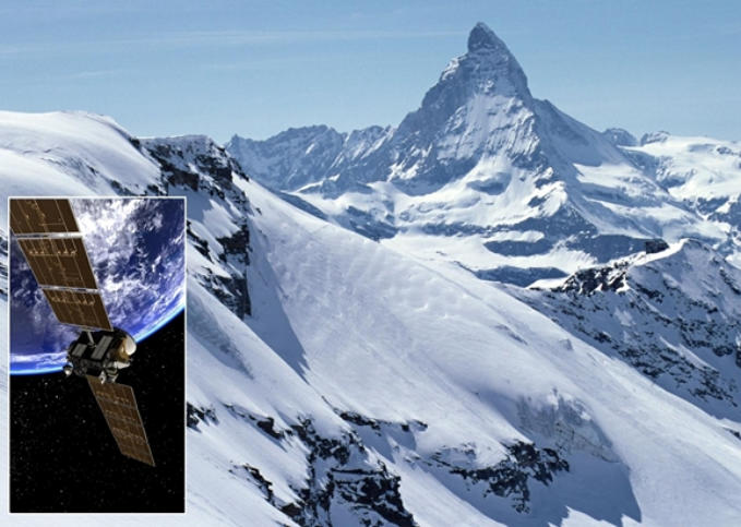
Recent studies of the data from the GOCE (Gravity Field and Steady State Ocean Circulation Explorer), that operated from 2009 to 2013, provided the detailed analysis of 'cratons', stable, rocky remains found in the region that separates the crust and mantel in what is called the lithosphere in Antarctica. These cratons are rocky cores of the remains of ancient continents that have survived several billion years, overcoming the destructive engine of the world's plate tectonics. Cratons can be found on all the major continents today. They are often part of vast structures of what scientists call 'shields', where craton's rocks have been widely disbursed on the surface and composed of Precambrian crystalline debris, which may be covered by younger sedimentary rock. Cratons contain a grand record of the landmasses that had once existed on the Earth in past prehistoric epochs, and most were combined to form them that are now part of our modern geography. Insert: The GOCE (Gravity Field and Steady State Ocean Circulation Explorer) pictured in orbit in 2013. Using high definition imaging and radar the probe provided scientists with clear data on the ancient cratons and continental 'fingerprints'. Image: The Transantarctic Mountains Range's craton region. "The geological age of these structures can be greater than 600 million years and can date some 3 to 4.5 billion years," said Professor Wegener from his office in Helsinger's Geosciences Division, "Cratons are the footprints of continental histories. They are a window into the remote part of Earth's ancient past." The images from GOCE discovered the remains of at least three geological landmasses on Antarctica, ranging from the more recent Gondwana from 500 to 160 million years ago, Rodinia which may have come together and dominated some one billion years ago, or Columbia, another confirmed, evidenced supercontinent, that appears to have risen some 1.8 to 1.5 billion years ago. The Transantarctic Mountains separate East and West Antarctica. The rift system that formed them is caused by a movement of surface mass along the East Antarctic Craton. Antarctica has been called the "graveyard of continents" based on their remains dating geologically some three billion years. Other continental titans that scientists have observed in other cratons are Kenorland, which is thought to have existed some 2.4 billion years ago and Ur, which has been classified as the earliest ancient landmass from three billion years ago. Vaalbara, which is evidenced in the Yilgarn Craton, is more of a speculation than an actual science finding, was found in Western Australia. The discovery on Antarctica created what has become a major combination of speculations and debates. Even as the South Polar landmass is buried in an average of 2 miles of snow and ice, the tools of ground penetrating radar, seismic data and magnetic readings can peel back those hidden layers and reveal the mysteries beneath. While there is much to understand about the Earth's most remote and inhospitable region, the ice, using these technical tools, yielded her secrets and may have provided a new discovery yet unimagined.


CURRENT ISSUE

Member Since May 1922
Explore
Discover
Find
Catalog
Publish
Reward
LONDON-ROME-BERLIN-MOSCOW-NAPLES


Recent Articles
Proud Sponsor of Bourne’s Journal
Sponsored Works


PAGE ONE
I
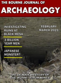
THE BOURNE JOURNAL OF
ARCHAEOLOGY


related posts
SHARE ON:
SHARE ON:


News of the World
© bOURNE uNIVERSITY 2021
New Model Reveals Evidence of a First Ancient
"Archean Continent" - Part One
Data from a NASA and ESA satellites imaging Antarctica's graveyard of age old continental remains has uncovered the ancient cratons of an Archean landmass. The first continent of Yidath, as rendered by geological artists based on craton and deep sea radar investigations from Australia on to the shores of Antarctica. Preliminary evidence shows very highly developed organic structures and atmospheric evidences, based on fossils discovered in Antarctica. During the modern area. the theory that the Archean Eon - from nearly 4.0 billions years ago - was preceded by the great geological upheavals and a molten state of the Hadean Eon has been accepted by academics and scientific circles alike. The earth's atmosphere, according to theory, had no free oxygen but was composed of nitrogen and methane. The crusts had begun to form. The primitive oceans began to appear during the earliest Archean (Eoarchean Era) with abundant volcanoes outgassing with the condensation for water. The carbon dioxide flows from these same volcanoes also contributed to the creation of the world's atmosphere, ozone layer and great oceanic ridges that formed thick oceanic plateaus. The globe then cooled, gradually providing the stable environment needed for early landforms and life to arise - prkaryotic microbes - which appeared some 3.5-3.7 billion years ago. Current theories suggest the Archean Earth of four billion years ago was beginning to cool down and see the formation of continents, the stable formation of an atmosphere of methane and oceans trapping oxygen in water form. Nearly 2.7 billion years ago, bluish- green microscopic organisms called cyanobacteria began to flourish in Earth's oceans. The moon began to form during this period. But with the analysis of records from Karvon University, using data from NASA’s newest satellite mission, the Ice, Cloud and land Elevation Satellite-2 (ICESat-2), having provided detailed geological images of Antarctica from space, evidence from previous satellites has shed light on a mystery that may question this geological speculation. The European Space Agency's Gravity Field and Ocean Circulation Explorer program was discontinued over six years ago and was studying how gravitational fields effect areas of the Earth. This also included the investigation of geological data from Landsat 8 launched in 2013 and the Terra satellite launched into Earth orbit by NASA in 1999. Using Japan's Advanced Spaceborne Thermal Emission and Reflection Radiometer (ASTER), the Terra satellite provided data used to create detailed maps of surface height elevations of land, emissivity, reflectance, and elevation. But with the help of data from these discontinued European and American satellites, not only had scientists discovered that East Antarctica has large mass of continental remains from the prehistoric past, but that neighboring landmasses like Australia and India could contain evidences of a first, unknown and unspeculated Archean continent. Photo: Geological continental barrier in southern Africa (Kaapval Craton). Current geological theories indicate the first modern landmass that formed was Pangea. Pangea was a supercontinent that arose during the late Paleozoic and early Mesozoic eras. It assembled from earlier continental fragments 335 million years ago, and fragmented itself about 175 million years ago. Ur, a proposed first Archean continent with some evidence, had been accepted to be the stable 'first' based on geological cratons. Scientists have created stunning 3-D maps of the southernmost Earth's tectonic crust substructures and have found that these continent's coastlines, when fractured crusts based on geological similarities are assembled from various coastlines shows how this hypothetical landmass of the ancient Archean supercontinent was assembled and then spectacularly destroyed. The scientists, led by Alfred Wegener, a geophysicist at West Ashington University in Helsinger, Denmark, announced their research findings later this year in Science Daily News. "If our theory proves to be correct, it may require revision to many aspects of our understanding of the Earth's geological and prehistoric histories, including the epochs of the past continents and possibly even the onset of plate tectonics."AN ANTARCTIC DISCOVERY
Recent studies of the data from the GOCE (Gravity Field and Steady State Ocean Circulation Explorer), that operated from 2009 to 2013, provided the detailed analysis of 'cratons', stable, rocky remains found in the region that separates the crust and mantel in what is called the lithosphere in Antarctica. These cratons are rocky cores of the remains of ancient continents that have survived several billion years, overcoming the destructive engine of the world's plate tectonics. Cratons can be found on all the major continents today. They are often part of vast structures of what scientists call 'shields', where craton's rocks have been widely disbursed on the surface and composed of Precambrian crystalline debris, which may be covered by younger sedimentary rock. Cratons contain a grand record of the landmasses that had once existed on the Earth in past prehistoric epochs, and most were combined to form them that are now part of our modern geography. Insert: The GOCE (Gravity Field and Steady State Ocean Circulation Explorer) pictured in orbit in 2013. Using high definition imaging and radar the probe provided scientists with clear data on the ancient cratons and continental 'fingerprints'. Image: The Transantarctic Mountains Range's craton region. "The geological age of these structures can be greater than 600 million years and can date some 3 to 4.5 billion years," said Professor Wegener from his office in Helsinger's Geosciences Division, "Cratons are the footprints of continental histories. They are a window into the remote part of Earth's ancient past." The images from GOCE discovered the remains of at least three geological landmasses on Antarctica, ranging from the more recent Gondwana from 500 to 160 million years ago, Rodinia which may have come together and dominated some one billion years ago, or Columbia, another confirmed, evidenced supercontinent, that appears to have risen some 1.8 to 1.5 billion years ago. The Transantarctic Mountains separate East and West Antarctica. The rift system that formed them is caused by a movement of surface mass along the East Antarctic Craton. Antarctica has been called the "graveyard of continents" based on their remains dating geologically some three billion years. Other continental titans that scientists have observed in other cratons are Kenorland, which is thought to have existed some 2.4 billion years ago and Ur, which has been classified as the earliest ancient landmass from three billion years ago. Vaalbara, which is evidenced in the Yilgarn Craton, is more of a speculation than an actual science finding, was found in Western Australia. The discovery on Antarctica created what has become a major combination of speculations and debates. Even as the South Polar landmass is buried in an average of 2 miles of snow and ice, the tools of ground penetrating radar, seismic data and magnetic readings can peel back those hidden layers and reveal the mysteries beneath. While there is much to understand about the Earth's most remote and inhospitable region, the ice, using these technical tools, yielded her secrets and may have provided a new discovery yet unimagined.


THE BOURNE JOURNAL OF
ARCHAEOLOGY


PAGE ONE
I


Recent Articles

Sponsored Works


related posts
SHARE ON:
SHARE ON:
Proud Sponsor of Bourne’s Journal
© bOURNE uNIVERSITY 2021
New Model Reveals
Evidence of a First Ancient
"Archean Continent" - Part
One
Data from a NASA and ESA satellites imaging Antarctica's graveyard of age old continental remains has uncovered the ancient cratons of an Archean landmass. The first continent of Yidath, as rendered by geological artists based on craton and deep sea radar investigations from Australia on to the shores of Antarctica. Preliminary evidence shows very highly developed organic structures and atmospheric evidences, based on fossils discovered in Antarctica. During the modern area. the theory that the Archean Eon - from nearly 4.0 billions years ago - was preceded by the great geological upheavals and a molten state of the Hadean Eon has been accepted by academics and scientific circles alike. The earth's atmosphere, according to theory, had no free oxygen but was composed of nitrogen and methane. The crusts had begun to form. The primitive oceans began to appear during the earliest Archean (Eoarchean Era) with abundant volcanoes outgassing with the condensation for water. The carbon dioxide flows from these same volcanoes also contributed to the creation of the world's atmosphere, ozone layer and great oceanic ridges that formed thick oceanic plateaus. The globe then cooled, gradually providing the stable environment needed for early landforms and life to arise - prkaryotic microbes - which appeared some 3.5-3.7 billion years ago. Current theories suggest the Archean Earth of four billion years ago was beginning to cool down and see the formation of continents, the stable formation of an atmosphere of methane and oceans trapping oxygen in water form. Nearly 2.7 billion years ago, bluish-green microscopic organisms called cyanobacteria began to flourish in Earth's oceans. The moon began to form during this period. But with the analysis of records from Karvon University, using data from NASA’s newest satellite mission, the Ice, Cloud and land Elevation Satellite-2 (ICESat-2), having provided detailed geological images of Antarctica from space, evidence from previous satellites has shed light on a mystery that may question this geological speculation. The European Space Agency's Gravity Field and Ocean Circulation Explorer program was discontinued over six years ago and was studying how gravitational fields effect areas of the Earth. This also included the investigation of geological data from Landsat 8 launched in 2013 and the Terra satellite launched into Earth orbit by NASA in 1999. Using Japan's Advanced Spaceborne Thermal Emission and Reflection Radiometer (ASTER), the Terra satellite provided data used to create detailed maps of surface height elevations of land, emissivity, reflectance, and elevation. But with the help of data from these discontinued European and American satellites, not only had scientists discovered that East Antarctica has large mass of continental remains from the prehistoric past, but that neighboring landmasses like Australia and India could contain evidences of a first, unknown and unspeculated Archean continent. Photo: Geological continental barrier in southern Africa (Kaapval Craton). Current geological theories indicate the first modern landmass that formed was Pangea. Pangea was a supercontinent that arose during the late Paleozoic and early Mesozoic eras. It assembled from earlier continental fragments 335 million years ago, and fragmented itself about 175 million years ago. Ur, a proposed first Archean continent with some evidence, had been accepted to be the stable 'first' based on geological cratons. Scientists have created stunning 3-D maps of the southernmost Earth's tectonic crust substructures and have found that these continent's coastlines, when fractured crusts based on geological similarities are assembled from various coastlines shows how this hypothetical landmass of the ancient Archean supercontinent was assembled and then spectacularly destroyed. The scientists, led by Alfred Wegener, a geophysicist at West Ashington University in Helsinger, Denmark, announced their research findings later this year in Science Daily News. "If our theory proves to be correct, it may require revision to many aspects of our understanding of the Earth's geological and prehistoric histories, including the epochs of the past continents and possibly even the onset of plate tectonics."AN ANTARCTIC DISCOVERY
Recent studies of the data from the GOCE (Gravity Field and Steady State Ocean Circulation Explorer), that operated from 2009 to 2013, provided the detailed analysis of 'cratons', stable, rocky remains found in the region that separates the crust and mantel in what is called the lithosphere in Antarctica. These cratons are rocky cores of the remains of ancient continents that have survived several billion years, overcoming the destructive engine of the world's plate tectonics. Cratons can be found on all the major continents today. They are often part of vast structures of what scientists call 'shields', where craton's rocks have been widely disbursed on the surface and composed of Precambrian crystalline debris, which may be covered by younger sedimentary rock. Cratons contain a grand record of the landmasses that had once existed on the Earth in past prehistoric epochs, and most were combined to form them that are now part of our modern geography. Insert: The GOCE (Gravity Field and Steady State Ocean Circulation Explorer) pictured in orbit in 2013. Using high definition imaging and radar the probe provided scientists with clear data on the ancient cratons and continental 'fingerprints'. Image: The Transantarctic Mountains Range's craton region. "The geological age of these structures can be greater than 600 million years and can date some 3 to 4.5 billion years," said Professor Wegener from his office in Helsinger's Geosciences Division, "Cratons are the footprints of continental histories. They are a window into the remote part of Earth's ancient past." The images from GOCE discovered the remains of at least three geological landmasses on Antarctica, ranging from the more recent Gondwana from 500 to 160 million years ago, Rodinia which may have come together and dominated some one billion years ago, or Columbia, another confirmed, evidenced supercontinent, that appears to have risen some 1.8 to 1.5 billion years ago. The Transantarctic Mountains separate East and West Antarctica. The rift system that formed them is caused by a movement of surface mass along the East Antarctic Craton. Antarctica has been called the "graveyard of continents" based on their remains dating geologically some three billion years. Other continental titans that scientists have observed in other cratons are Kenorland, which is thought to have existed some 2.4 billion years ago and Ur, which has been classified as the earliest ancient landmass from three billion years ago. Vaalbara, which is evidenced in the Yilgarn Craton, is more of a speculation than an actual science finding, was found in Western Australia. The discovery on Antarctica created what has become a major combination of speculations and debates. Even as the South Polar landmass is buried in an average of 2 miles of snow and ice, the tools of ground penetrating radar, seismic data and magnetic readings can peel back those hidden layers and reveal the mysteries beneath. While there is much to understand about the Earth's most remote and inhospitable region, the ice, using these technical tools, yielded her secrets and may have provided a new discovery yet unimagined.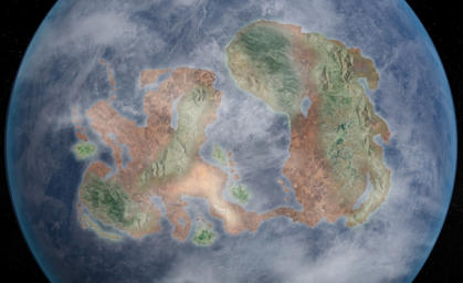


THE BOURNE JOURNAL OF
ARCHAEOLOGY


PAGE ONE
I
PAGE ONE
I
SHARE ON:
SHARE ON: